Home /
Expert Answers /
Earth Sciences /
longitude-and-latitude-finding-locations-on-earth-background-to-locate-places-or-features-on-the-ea-pa369
(Solved): longitude and latitude Finding Locations on Earth Background: To locate places or features on the Ea ...
longitude and latitude
Finding Locations on Earth Background: To locate places or features on the Earth a system of grid lines was established. Lines which run north \& south are called lines of longitude and they are used to measure distances west or east from the prime meridian ( longitude). Lines that run east to west are used to measure distance north \& south of the equator latitude). The intersection of these two lines marks the location of a place or feature. Objective: to show by completion of this activity a rudimentary understanding of longitude \& latitude - to show an understanding of how latitude can be determined by use of the North star (Polaris) - to show an understanding of how longitude can be determined by use of a clock Procedure: Part A. Longitude Refer to Fig.14-1 to complete questions 1 to 8
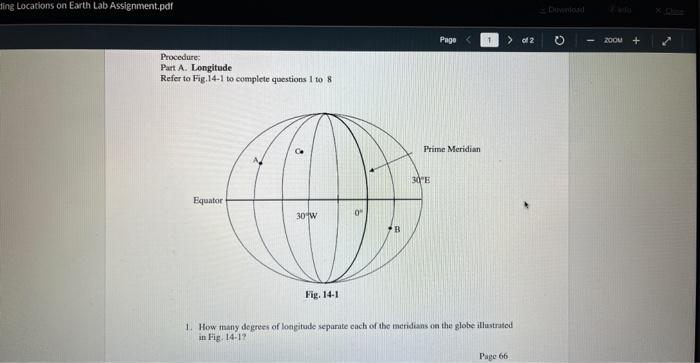
Procedure: Part A. Longitude Refer to Fig.14-1 to complete questions 1 to 8 1. How many degrees of longitude separite cach of the merideans on the globe illustrated in Firg. 14-1?
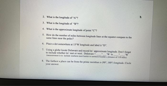
2. What is the longitude of " ? 3. What is the longitude of " "? 4. What is the approximate longitude of point " "? 5. How do the number of miles between longitude lines at the equator compare to the same lines near the poles? 6. Place a dot somewhere at longitude and label it " ". 7. Using a globe locate Delaware and record its' approximate longitude. Don't forget to include whether its' east or west. Delaware - W 'W to (measarement is to include southem most border so northem boorder a distance of 118 miles) 8. The farthest a place can be from the prime meridian is longitude. Circle your answer,
Expert Answer
(1) How many degree of longtude each of the meridiam on the globe illustrated ? Answer : The distance between lines of longitude on the World's surfa