Home /
Expert Answers /
Earth Sciences /
d-what-can-you-think-of-to-explain-the-very-thick-thousands-of-meters-of-rock-transgressive-sequ-pa475
(Solved): D. What can you think of to explain the very thick (thousands of meters of rock) transgressive sequ ...
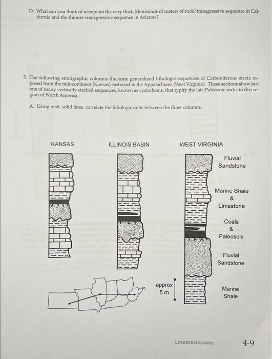
D. What can you think of to explain the very thick (thousands of meters of rock) transgressive sequence in Cal- ifornia and the thinner transgressive sequence in Arizona? 5. The following stratigraphic columns illustrate generalized lithologic sequences of Carboniferous strata ex- posed from the mid-continent (Kansas) eastward to the Appalachians (West Virginia). These sections show just one of many vertically stacked sequences, known as cyclothems, that typify the late Paleozoic rocks in this re- gion of North America. A. Using neat, solid lines, correlate the lithologic units between the three columns. KANSAS ILLINOIS BASIN approx 5m WEST VIRGINIA LITHOSTRATIGRAPHY Fluvial Sandstone Marine Shale & Limestone Coals & Paleosols Fluvial Sandstone Marine Shale 4-9
B. Cyclothems record sea-level cycles. What is the lithologic and stratigraphic evidence that you can use to iden- tify the regressive part of the cycle. C. Describe the lithologic and stratigraphic evidence that can be used to identify the transgressive phase of the cycle. D. How might you explain the presence of thinner limestone and an increase in coal-bed number and thickness toward the east? E. Late Paleozoic strata along the Appalachians may consist of as many as 50 vertically stacked cyclothems. Cy- clothems record a comparable number of sea-level cycles with an estimated average duration of approxi- mately 100,000 to 400,000 years each. These strata were deposited when continent-continent collision (the Appalachian or Alleghenian orogeny) was building the Appalachian and Ouachita Mountains, and when large areas of the Gondwanaland were covered by extensive glaciation. Speculate on the possible mecha- nisms responsible for the short-term sea-level cycles recorded in the North American cyclothems.
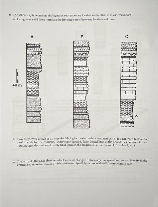
6. The following three marine stratigraphic sequences are located several tens of kilometers apart. A. Using neat, solid lines, correlate the lithologic units between the three columns. 40 m A 704 B C B. How might you divide or arrange the lithologies into formations and members? You will need to note the vertical scale for the columns. After some thought, draw dotted lines at the boundaries between formal lithostratigraphic units and neatly label them on the diagram (e.g, Formation 1, Member 1, etc.). C. The vertical lithofacies changes reflect sea-level changes. How many transgressions can you identify in the vertical sequence in column B? What relationships did you use to identify the transgressions?
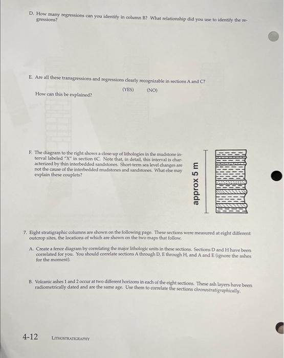
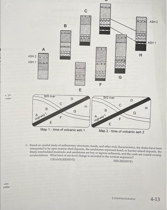
D. How many regressions can you identify in column B? What relationship did you use to identify the re- gressions? E. Are all these transgressions and regressions clearly recognizable in sections A and C? (YES) (NO) How can this be explained? F. The diagram to the right shows a close-up of lithologies in the mudstone in- terval labeled "X" in section 6C. Note that, in detail, this interval is char- acterized by thin interbedded sandstones. Short-term sea level changes are not the cause of the interbedded mudstones and sandstones. What else may explain these couplets? 7. Eight stratigraphic columns are shown on the following page. These sections were measured at eight different outcrop sites, the locations of which are shown on the two maps that follow. approx 5 m A. Create a fence diagram by correlating the major lithologic units in these sections. Sections D and H have been correlated for you. You should correlate sections A through D, E through H, and A and E (ignore the ashes for the moment). B. Volcanic ashes 1 and 2 occur at two different horizons in each of the eight sections. These ash layers have been radiometrically dated and are the same age. Use them to correlate the sections chronostratigraphically. 4-12 LITHOSTRATIGRAPHY
s, yo inter OSL eithe BIOSTRAB ASH 2 ASH 1 A BIG river B A Highway 1 C F LL D G E O H E Map 1- time of volcanic ash 1 LL BIG river B A Highway 1 G C F D H E Map 2-time of volcanic ash 2 LITHOSTRATIGRAPHY ASH 2 ASH 1 H C. Based on careful study of sedimentary structures, fossils, and other rock characteristics, the shales have been interpreted to be open marine-shelf deposits, the sandstones represent beach or barrier-island deposits, the thinly interbedded mudrocks and sandstones are bay or lagoon sediments, and the coals are coastal-swamp accumulations. What kind of sea-level change is recorded in the vertical sequences? (REGRESSIVE) (TRANSGRESSIVE) 4-13